


Karst is a type of landscape where the dissolving of the bedrock has created sinkholes, sinking streams, caves, springs, and other characteristic features. Karst is associated with soluble rock types such as limestone, marble, and gypsum. In general, a typical karst landscape forms when much of the water falling on the surface interacts with and enters the subsurface through cracks, fractures, and holes that have been dissolved into the bedrock. After traveling underground, sometimes for long distances, this water is then discharged from springs, many of which are cave entrances.
KARST LANDSCAPE IS ASSOCIATED WITH THE FOLLOWING FEATURES
actually the features has been divided into two categories
lets see few example on karst region subsurface features
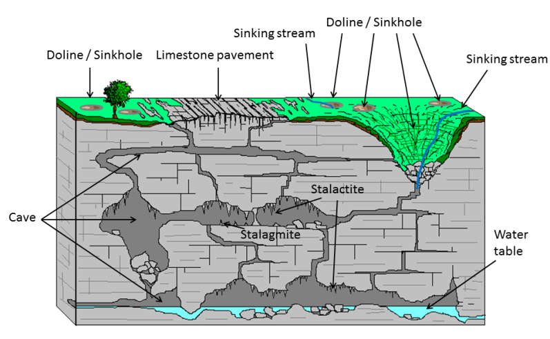
observe the following diagram from wekipedia

diagram 1, showing the karst subsurface features.
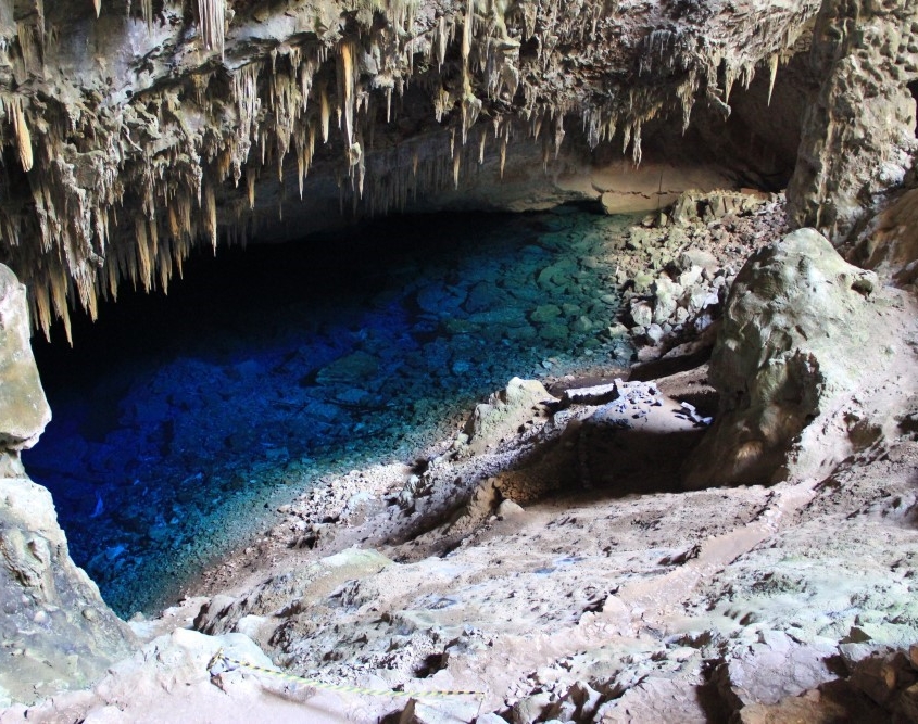
1 stalactites
As we have said, stalactites are speleothems that originate from the ceiling and continue to “grow” downward towards the ground. They are rock formations that have a duct in the center through which water continues to circulate with minerals, which allows them to continue growing and allows the formation of stalagmites
observe the following diagram
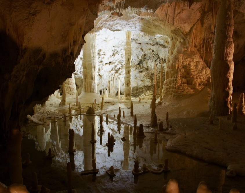
2 stalagmites
Stalagmites are speleothems originated in the soil and, unlike stalactites, they grow ascendingly. Also, they do not have the central duct such as stalactites but increase in size due to calcite or calcium carbonate residues. They are usually solid shapes much more rounded and irregular than stalactites. observe the following diagram
How stalactites and stalagmites form?
Stalactites and stalagmites form due to a process called chemical precipitation. These speleothems are formed thanks to the precipitation of minerals that dissolve in water. When water seeps through the cracks in the rocks, it dissolves the karst minerals from them in water. Usually, these types of minerals are carbonates, such as calcite and dolomite, or certain sulfates such as gypsum. When the water enters a cavity, the dissolution of the minerals is modified again, turning it into a solid inside the cavity.
When rainwater is filtered and dissolved it is obtained calcium bicarbonate, which is very soluble in water. Therefore, when drops of this water seep into the caves, a reaction takes place through which carbon dioxide escapes and calcium carbonate precipitates, thus generating the sediment that over time will become what we know as stalactites
In stalactites, water continues to drip when it seeps through the duct inside, and therefore allows stalagmites to form. For this reason, stalactites and stalagmites are generally faced. At the moment when both speleothems come together, we will find a structure called a column or pillar.
It is estimated that for them to grow more than two and a half centimeters, it takes between 4000 and 5000 years but it also allows measuring the atmospheric and geological conditions of thousands of years ago.
3 natural pillars
The pillars result from the union of a stalactite and a stalagmite
4 anemolytes
Anemolytes, meanwhile, are also called deflected stalactites. This is because they are not completely vertical but are inclined by the action of air currents during their formation.
5 plates
The discs or plates are speleothems formed due to the action of the water that comes out of a crack in the rock. It is then when the carbonate accumulates on the edges of the said crack that acquires the characteristic shape that resembles a disk or plate.
let see the few examples on karst region surface features.
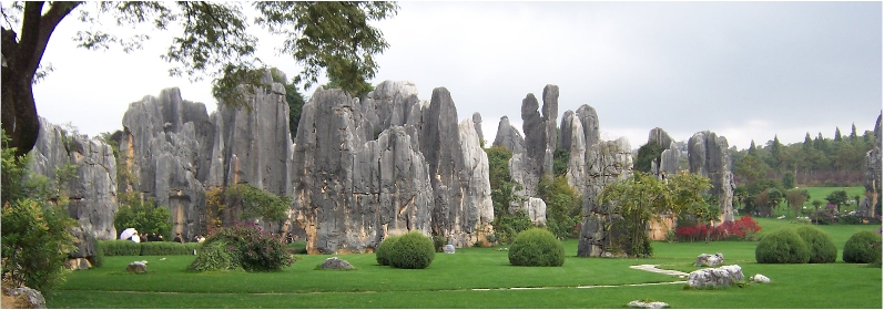
the diagram above shows the karst area,in runan stone forest in china
Surface Karst Features
1 Dolines
Dolines are closed depressions in karst areas, which are usually circular in outline. Dolines may be produced by solution of rock close to the surface, or by the roof of a cave collapsing. Solution dolines tend to have a smooth funnel shape, while collapse dolines often have cliffed sides. Streams often sink underground through dolines.
2 Dry Valleys
In karst areas, most of the drainage is underground. As they flow onto the limestone, streams sink underground and travel through caves. In dry valleys, the surface streams flow in times of heavy rain only, when the underground drainage is unable to cope with the flow. Dry valleys often contain large boulders, but little fine sediment as their streams only flow during floods, when there is too much energy to deposit mud and silt.

3 Grikes
Vertical joints and bedding planes in limestone can be widened by solution to form deep elongated slots. These slots are called grikes.

4 Solution Flutes
Falling rain is able to disolve limestone, because it contains carbon dioxide from the atmosphere. Rainwater runs down limestone and sculptures it, each run of water dissolving a groove or solution flute into the limestone. This type of fluting, consisting of parallel vertical grooves, is known by its German name, Rillenkarren.

5 Streamsinks
A streamsink is the point at which a surface stream disappears underground
 .
.
6 Resurgence
The resurgence is the point of reappearance from underground, of a stream, which has a course on the surface higher up.
7 Blind Valley
A blind valley is one that is closed abruptly, at its lower end, by a cliff or slope facing up the valley. It may have a perennial or intermittent stream, which sinks at its lower end, or it may be a dry valley.
8 Steephead
A steephead is a steep-sided valley in karst, generally short, ending abruptly upstream, where a stream emerges (or emerged in the past).
to be continued
KARST LANDSCAPE IS ASSOCIATED WITH THE FOLLOWING FEATURES
actually the features has been divided into two categories
- surface features
subsurface features
lets see few example on karst region subsurface features
observe the following diagram from wekipedia
diagram 1, showing the karst subsurface features.
1 stalactites
As we have said, stalactites are speleothems that originate from the ceiling and continue to “grow” downward towards the ground. They are rock formations that have a duct in the center through which water continues to circulate with minerals, which allows them to continue growing and allows the formation of stalagmites
observe the following diagram
2 stalagmites
Stalagmites are speleothems originated in the soil and, unlike stalactites, they grow ascendingly. Also, they do not have the central duct such as stalactites but increase in size due to calcite or calcium carbonate residues. They are usually solid shapes much more rounded and irregular than stalactites. observe the following diagram
How stalactites and stalagmites form?
Stalactites and stalagmites form due to a process called chemical precipitation. These speleothems are formed thanks to the precipitation of minerals that dissolve in water. When water seeps through the cracks in the rocks, it dissolves the karst minerals from them in water. Usually, these types of minerals are carbonates, such as calcite and dolomite, or certain sulfates such as gypsum. When the water enters a cavity, the dissolution of the minerals is modified again, turning it into a solid inside the cavity.
When rainwater is filtered and dissolved it is obtained calcium bicarbonate, which is very soluble in water. Therefore, when drops of this water seep into the caves, a reaction takes place through which carbon dioxide escapes and calcium carbonate precipitates, thus generating the sediment that over time will become what we know as stalactites
In stalactites, water continues to drip when it seeps through the duct inside, and therefore allows stalagmites to form. For this reason, stalactites and stalagmites are generally faced. At the moment when both speleothems come together, we will find a structure called a column or pillar.
It is estimated that for them to grow more than two and a half centimeters, it takes between 4000 and 5000 years but it also allows measuring the atmospheric and geological conditions of thousands of years ago.
3 natural pillars
The pillars result from the union of a stalactite and a stalagmite
4 anemolytes
Anemolytes, meanwhile, are also called deflected stalactites. This is because they are not completely vertical but are inclined by the action of air currents during their formation.
5 plates
The discs or plates are speleothems formed due to the action of the water that comes out of a crack in the rock. It is then when the carbonate accumulates on the edges of the said crack that acquires the characteristic shape that resembles a disk or plate.
let see the few examples on karst region surface features.
the diagram above shows the karst area,in runan stone forest in china
Surface Karst Features
1 Dolines
Dolines are closed depressions in karst areas, which are usually circular in outline. Dolines may be produced by solution of rock close to the surface, or by the roof of a cave collapsing. Solution dolines tend to have a smooth funnel shape, while collapse dolines often have cliffed sides. Streams often sink underground through dolines.
2 Dry Valleys
In karst areas, most of the drainage is underground. As they flow onto the limestone, streams sink underground and travel through caves. In dry valleys, the surface streams flow in times of heavy rain only, when the underground drainage is unable to cope with the flow. Dry valleys often contain large boulders, but little fine sediment as their streams only flow during floods, when there is too much energy to deposit mud and silt.
3 Grikes
Vertical joints and bedding planes in limestone can be widened by solution to form deep elongated slots. These slots are called grikes.
4 Solution Flutes
Falling rain is able to disolve limestone, because it contains carbon dioxide from the atmosphere. Rainwater runs down limestone and sculptures it, each run of water dissolving a groove or solution flute into the limestone. This type of fluting, consisting of parallel vertical grooves, is known by its German name, Rillenkarren.
5 Streamsinks
A streamsink is the point at which a surface stream disappears underground
.6 Resurgence
The resurgence is the point of reappearance from underground, of a stream, which has a course on the surface higher up.
7 Blind Valley
A blind valley is one that is closed abruptly, at its lower end, by a cliff or slope facing up the valley. It may have a perennial or intermittent stream, which sinks at its lower end, or it may be a dry valley.
8 Steephead
A steephead is a steep-sided valley in karst, generally short, ending abruptly upstream, where a stream emerges (or emerged in the past).
to be continued